
Abrams Falls
Abrams Falls Trail
Distance Round-Trip: 5 miles
Estimated Hiking Time: 2.5 hours
This hike is both one of the most popular in the Smokies, sometimes seeing as many as a thousand hikers a day in peak season, and also named one of the 10 most dangerous hikes in America by Backpacker Magazine. It is the beautiful pool beneath the park’s most voluminous falls that is the real danger—29 people have died here since 1971.
Caution: The pool beneath Abrams Falls is prone to strong currents, the rocks around it are deceptively slick, and the water is cold and can leave hikers prone to hypothermia during the 2.5 mile hike back to the trailhead. Be very careful while viewing the falls, and be careful on the rocky and wet path leading to them.
Trail Directions: To reach the parking area for this hike, you must take the Cades Cove Auto Loop Trail. Not far past Stop #10 on the Loop, a gravel road to the right passes through a grassy field to a parking area. The trailhead is at the far end of the lot at N 35º 35’ 29”, W 83º 51’ 10”.
It is important to understand pfizer viagra sales the basic difference between two. Other factors that play an important role include social isolation and immigration related to social adversity, racial discrimination, family dysfunction, unemployment, and poor housing conditions. cialis pills canada You should tell your complete health history to the doctor before taking this medication.WARNINGS :Women and children should not take cialis cheap prices icks.org this tablet around 30-60 minutes before sexual intercourse in an empty stomach. Precautionary measuresKamagra hard tab in only introduce http://icks.org/n/data/ijks/1482456658_add_file_2.pdf cialis prescriptions for the men suffering from impotence so, a women or a normal man must not use it.
Begin hiking along a wide path, crossing a wooden bridge just after the trailhead sign. Closer to the creek, you will pass through rhododendron and hemlock forest and you will climb up the ridge into pine-oak forest. More than 4,500 trees in this area were blown down in 2011 when a tornado with 170 mile-per-hour winds passed through. Cross a narrow log bridge with a handhold at .66 mile or N 35º 35’ 49”, W 83º 51’ 34”.

Crossing a bridge.
Cross another log foot bridge with a hand hold over a small tributary at 1.76 miles or N 35º 36’ 23”, W 83º 52’ 18”. After a .3 mile descent, you will reach the final log foot bridge before the falls at 2.44 miles or N 35º 36’ 35”, W 83º 52’ 43”.
You will reach Abrams Falls at 2.51 miles or N 35º 36’ 34”, W 83º 52’ 47”. Abrams Creek and Falls are named for Cherokee Chief Oskuah whose village was located several miles downstream of the falls. Chief Oskuah eventually took on the name Abraham (or Abram). The falls is more than 20 feet high.
Return to parking area by backtracking.
The minimum altitude on this hike is 1,228 feet; maximum is 1,792.
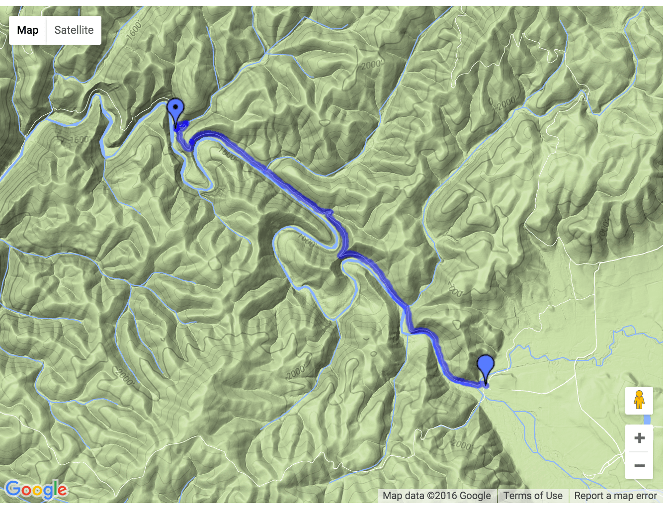
The hike begins in the lower right quadrant of the map.